Wednesday, January 5, 2011

Cartagena to Panama

Lahaina Roads at anchor in Cocos Bandera


December 25 - Cholon

We left Club Nautico in the morning and made our way to the fuel dock to top off the tanks in preparation for an overnight trip, this time to the San Blas Islands. Soon we were heading out through the lengthy channel to the open sea.

Cholon was a mere 15 miles or so southwest. The winds were from the starboard quarter, so we put up a headsail and hugged the coastline. A boat we knew from Club Nautico, Shiver, was ahead of us and also was going to spend a few days in Cholon.

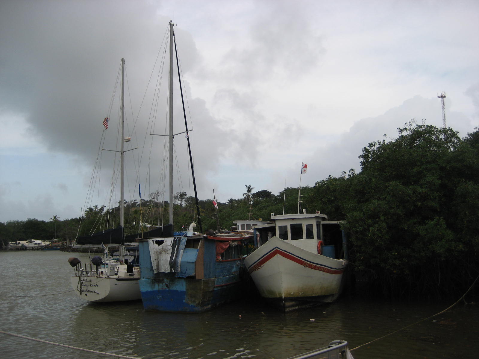
We made our way into the bay with help of Pete, on the yacht Avitar and by following Shiver. But the only tricky part of the process was getting through a very narrow gap that led to the expansive bay, known as Baru.

Coming into to the bay at Cholon

That evening we went to a happy hour held on an old fishing boat owned by an expat, Robert, who also happed to own a home that overlooks the bay (there were plans for a potluck dinner at his house the following day - Christmas). We were warming up to this place quickly.

The following day, the potluck turned out to be a delicious and fun - turkey, stuffing, cranberry sauce, many side dishes and lots of tasty desserts. The view from Robert’s house was nothing less than spectacular. To one side, the entire bay of Baru was visible while the other side of the house offered up a view of another bay. We had a grand time eating and mixing with the other cruisers and several hours later, dinghied back to Lahaina Roads satiated and ready for an afternoon nap. 
Christmas feast

The next morning was our overnight sail to the San Blas Islands, about 140 miles away.   

December 27 - Isla Pinos, San Blas

After a brutal, at times frightening, overnight sail from Cholon, we are safely at anchor off of Isla Pinos, one of the more remote islands in the San Blas chain. 
 
We left Cholon under sunny and warm conditions, motoring through the tiny pass as we made our way out to sea. Although the seas and winds were much like what we had encountered before, with seas from the quarter and winds from abaft, the ride wasn’t too bad. We even had cocktails and barbecued a pork loin for dinner. 

That all changed later that evening. It started with a few sprinkles. Those sprinkles eventually blossomed into a storm, with high seas, winds above thirty knots and a spectacular (but scary) thunder and lightening show. Hollywood would have found it challenging to emulate. 

At times we were right in the center of the lightening, with bright flashes continually exploding around us like powerful strobe lights. Lightening occurred so frequently and furiously that several seconds would elapse before nighttime darkness would return. In a way it was as if hundreds of photographers were snapping photos with super bright flash bulbs right in our faces. I had never ever experienced anything like it.

It’s one thing to sit at home and watch a lightning show but quite another thing to be on a sailboat at sea when your mast is the very tallest target around for lightning to strike. Dave and I discovered later that we both had been mulling the possibility of needing to abandon ship and what we’d have to do to prepare - getting the dinghy ready, the life raft in the water, essential gear and supplies etc. To us, it was unexplainable how we didn’t get zapped with a bolt of lightening. But somehow, we made it through the wicked cauldron and lived to talk about it.    
 
In the morning the weather improved a little and soon we spotted Isla Pinos. The approach to the island was straightforward (that’s why Sir Francis Drake used it in 1571 to plan an attack on the town of Nombre de Dios). There was no perilous outer reef to navigate through to get to the island. We headed towards the south side of the island and found a spot in the lee of it. We anchored in twenty feet of water. It was noon - time for a beer and some shut eye. 

The following morning we took the dinghy into the village. Diane and I had seen the typical Kuna village before and this was not much different from what we had experienced. But when it came to buying a mola, we encountered a new experience. Earlier, we had asked one of the women about purchasing molas and she had responded by showing us a few samples of what she had made. But when it came to buying, it apparent that she couldn’t just sell us a mola - the village chief would have to be involved.

Villagers laughing at Barry's funny accent 

First we would have to get the approval of the chief. So someone went out to fetch him. He was out somewhere on the island. After about a half an hour, he returned, and in pretty good English, he said that he would get all the families to show their molas in the village square.

A few minutes later, women with their children started to appear with their molas, laying them all out on the ground for us to see. There really was no bargaining - prices were set but they were very fair. We ended up buying several molas and had a great time experiencing the custom.

The chief's home


No sooner had we gotten back to the boat, when the chief came paddling up in his dugout canoe - we had seen his house and now he wanted to see our boat. We invited him aboard and gave him the grand tour of Lahaina Roads. He was impressed with the two bathrooms we had aboard and liked our bar cabinet - Feliz Ano Nuevo, he said with a smile. 

Dave and the village chief

We sent the chief off on his canoe a bit later and pulled up anchor. It had been a very interesting and eye-opening day on our first day in the Kuna Yalas. We headed passed the village through the reefs towards the next island, Ustupu. 

December 29 - Ustupu and Onward

We navigated our way through the narrow pass between the Isla Pinos and the reef on the mainland and reached open water. At first it was a bit unnerving because the GPS and our Panama cruising book charts were different. The odd thing was that for the first time, it was the GPS that was wrong. A bit unsettling but it was something we had to get used to because all the GPS readings from here on seemed to be off by several hundred yards. (To clarify, the GPS lat/long readings were correct - the GPS chart overlay was the part that was incorrect.) 

A short while into our motoring, we passed nearby the island of Manitupu, but decided to proceed to Achutupu (otherwise known as Dog Island). We were welcomed by the locals as we walked the island, but truly the welcome had an agenda - to sell us molas.  

We walked onward and watched a basketball game that actually was pretty good. One of the locals told us that both teams were composed of family members  that was a tradition.  These players all played as they had been team members of a varsity high school basketball team. 

Diane pondering her next mola acquisition

After watching the game for a while, we walked back towards where the women were showing off their molas - many had appeared and the selection was impressive. The molas are very colorful pieces of cloth consisting of several different layers of cloth. We bought several of them, some with patterns of birds, fish, fruit, the sun and moon and other more abstract forms.

We again pulled up anchor and headed for San Ignacio de Tupile. We passed by Ailigandi and Bahia Golondrina, seeing a couple of yachts anchored in the latter bay. After a couple of hours we anchored in front of San Ignacio, but not without the assistance of a local - there were lots of coral heads in the way of which we found a couple, by bouncing right into them. They were more difficult to see than normal due to all the rainfall that had occurred making the water murky and muddy. But finally we did get situated.

As soon as we anchored some young boys popped over in their canoes to check us out. They were very friendly and wanted to check us out. When we went to shore, we offered them a tow to shore, which they took us up on. They, as well as we, had a fun time.

San Ignacio de Tupile was a clean, well planned island, much different from Isla Pinos and others we had seen. The people seemed very happy, with lots of folks sitting outside of their thatched homes enjoying the late afternoon. In spite of our guide saying that there were cold beers and restaurants on the island, the only thing we found was a place to buy a case of warm beer. One lady offered to cook us a lobster meal, but it was bits of lobster with plantains - not really what we had in mind for dinner. But we did end up buying several molas from her, which seemed to make her extremely happy.
Kristi and Diane with a mola weaver


After a while (and a few more mola purchases) we returned to the boat, had our cocktails and prepared a meal of salad, pasta and pork chops accompanied with an Argentinean Malbec. A fine way to finish off the evening.  

We got up in the morning and soon after coffee were pulling up anchor. Our initial objective was going to be Isla Tigre, but once we approached the island, we concluded that it was “just” another traditional island. This meant, no swimming around the boat because of the raw sewage emanating from the island and we were looking forward to white sandy beaches with swimming and snorkeling. We continued onward and set a course for the Cocos Bandero Cays, reportedly a group of extremely scenic islands, that lie within a protective outer barrier reef.

One thing I haven’t mentioned much about is the weather. Unfortunately, it hasn’t been optimal. The stormy weather we encountered on the way over to the San Blas Islands has mitigated but only to the extent that we aren’t being surrounded by bolts of lightening, the deafening sounds of thunder, all accompanied by torrential rains. 

The skies are cloudy and at times it rains. In the distance there is a misty haze and the water is tainted with a muddy green color - run off from the land and turbulence from the ocean. Still, we’re making the best of it. At least nature isn’t pelting us with torrential rains. 

We weaved our way through lots of corral reefs and tiny islands and finally came upon our new destination -  Cocos Bandero Cays. We spotted a number of other yachts anchored at Green Island and east Cocos. We had been aiming for a couple of islands in the west Cocos. 
Barry keeping an eye out for coral

We anchored at Orduptarboat after weaving our way past a couple of reefs. A little deeper than we typically like to anchor, the forty feet of depth forced us to lay out more chain than we liked to put out - it’s a lot of work hauling all that chain back in, in the morning! 

The upshot of the deal was that we had the island to ourselves. In fact, we had the three surrounding islands to ourselves. We got the dinghy in the water and visited two of the islands, each so small that we walked around each of them in no time. 

December 31 - Holandes Cays

The next morning, New Year’s Eve, we sailed to the Holandes Cays, four miles north, and found our way into a snug harbor behind a barrier reef and an a small, palm tree-lined island with white sandy beaches. 

Later in the day we took the dinghy to BBQ island, an idyllic white-sandy beach island another half-mile away. We walked, snorkeled and swam around the area. Nothing to write home about in beauty and uniqueness - lots of dead coral and the visibility was marginal.

The crew at Cocos Banderas

The most memorable part of the Holandes Cays was the fact that it was there that we spent New Year’s Eve. Kristi cooked a fabulous (and very tasty) chicken dinner including sparkly and glittery looking palms on a toothpick to liven up the appearance of the meal. Dinner was delicious but, unfortunately, did not embolden us enough to stay up until midnight. The latest some of us stayed up was 10:30pm. Pretty pitiful. 

In the morning, after our coffee, we pulled up anchor and headed northwest for Punta San Blas, a peninsula on the western edge of the Kuna Yala area. We passed by numerous islands including the Lemon Cays and El Porvenier. But when we got to the anchorage, we decided that the anchorage wasn’t as peaceful as the book may have led us to believe. We headed onwards.

Three hours later we sighted Miramar, a small village with a snug little harbor on a river. The entrance was treacherous - waves breaking on either side of us and no particular view of where to go once we made it through the pass. But as soon as we got into the tiny bay we turned to port into the river area and a few feet later, promptly ran aground. 
Lahaina Roads at Miramar

With the assistance of some local folks standing nearby, we were coached away from the middle of the river, veering off to starboard. After revving the engine up in reverse for a few minutes, we got off the sandbar and ended up side-tying to an old island trader boat. Jose, an English speaking military fellow, was critical in helping us out. Fun stuff - definitely the stuff that makes great memories.

January 2 - Miramar to Portobelo

It was a bit of touch-and-go leaving our side-tie in Miramar but we made it out of the tight anchorage without a hitch. Getting through the pass with large breaking waves on either side of us was a bit exhilarating and got our heart rates up. The boat would lurch upwards into a steep swell, only to head straight down another one. But quickly we got out into open water and were on our way to Portobelo.

Four hours later we were entering Portobelo, after an exciting sail along the coastline. Entering Portobelo’s harbor was banal after experiencing Miramar.  It was wide open - easy to understand why Columbus liked it so much when he sailed in here in 1502. 
Coming in to Portobello

After anchoring, we took a walk into town walked passed an area that had experienced a landslide just recently. There was lots of mud, debris and the remains of household goods strewn around the area. We found out later that eight people had died when the side of the hill had given way. 

Some of the devastation from the landslide

In the town we visited the Custom’s House and the Cathedral. But it was obvious that the town had seen better times. After being plundered and laid siege on by the likes of Morgan, Parker and Vernon, Portobelo had lost its luster along the way. What was left looked pretty shabby. A few pieces of the old forts still remain, but even parts of them are gone - some of the rock from the forts were used to build the Panama Canal. 

On the way back to the dinghy, we stopped for lunch at one of the  local restaurants and had a tasty chicken, rice and beans dish. We also found some cheap rum and wine at the local grocery store. What a productive day it had been!

December 3 - Portobello to Colon

Early the following morning, we headed out of the bay towards Colon, Panama. It was a sunny day with a mild breeze blowing out of the northeast. By noon we were at the entrance of the Colon harbor and headed for Shelter Bay Marina. A short time afterwards we were docked at the marina. We spotted several boats that we had encountered elsewhere including Cartagena and the ABC’s. 

In essence, the process of checking in to Panama and transiting the Canal requires an agent. One pays an agent to do all your legwork and to coordinate setting up a schedule with the Canal Authorities to be admeasured for the transit. We needed four sets of heavy duty line, an advisor and one additional line handler (there were four of us excluding the skipper) to go through the canal. We’d have to feed them and provide a place to sleep for the line handler. The advisor would leave at the end of the day. A new one would join us the following day to see us through the rest of the transit.     

Shelter Bay Marina is several grades up from Club Nautico in Cartagena. The docks are new and clean, it has a pool, Jacuzzi,  a laundry facility, showers, bathrooms, a restaurant and a bar. It is situated at the edge of a national forest reserve that has hundreds of types of native birds, monkeys, sloths, crocodiles and other wild animals. Docking here isn’t going to be a hardship.

January 5 - Shelter Bay Marina

We’ve been at Shelter Bay for a couple of relaxing days. We’ve had the boat measured and we’re scheduled to transit the canal starting tomorrow afternoon. We’ll have two additional people on the boat - a canal advisor and one more line-handler (who is prepared to dive into the water should the need arise - that could get exciting since there are crocodiles and strong currents in the canal lake).

The transit takes two days coming from the Caribbean side, while only one day from the Pacific. And that’ll be the next report. 


Thursday, December 23, 2010

Cartagena, Colombia


December 23 - Cartagena

We have now been in Cartagena for quite a while and we can happily report that we‘ve been enjoying the city but are ready to move on. Club Nautico has been fun, specially the happy hours. 

We've enjoyed meeting all the members of the cruising community and, it sure has been rewarding to get lots of good information on Cartagena as well as places we are planning to visit.

Dave listening to Steve from Music play some tunes.

We’ve put a lot of footsteps in the city’s old quarter, so much so that we can pretty much find our way around all the tiny, circuitous streets. Among the sights and museums we visited were the Museu de Oro and the Museu Naval, which in spite of not having much English posted, were very enlightening. We also toured the huge and impressive fort of San Felipe de Barajas.

Fort San Felipe de Barajas

The history of this area goes back thousands of years. Some of the indigenous cultures actually thrived right up until the Spanish arrived living along the coastal areas. They were sailors, fishermen, farmers and goldsmith (the latter was probably their downfall when the  Spanish found out). In the Museu de Oro we saw samples of what they were capable of making - they hammered out very intricate ornamental objects out of gold and platinum.


The colonial history of Cartagena goes back to 1533. That‘s when Pedro de Heredia founded the city. Apparently he waged a very successful campaign of plundering the Zenu Indians, including their “Mogote graves” after he found out that the graves often contained substantial amounts of gold. 

The future of the young city looked pretty good. But due to its success, only thirty years into its youth, the city started getting attacked by pirates and the English. After a few of these invasions and raids, the Spanish got wise and began to build forts to protect the city. That idea resulted in all the fortifications we see today (not that they always were successful in keeping out the invaders). 

Plaza Simon Bolivar

One last mention of the history of Cartagena is regarding a figure one often sees depicted here - Simon Bolivar. I don’t know much about him, but apparently he is viewed as a hero who led a number of the countries in South America to independence. 

Enough history.

A few days ago, Dave and I picked up Diane and Kristi at the airport. It was almost midnight - way beyond our bed time. But it all went like clockwork. We’ve since showed the girls around the city.

Barry, on the other hand, has been seeing a very nice Colombian lady who he met here at Club Nautico. They’ve hit it off real well, such that we haven’t seen much of him since we’ve been here.

The weather has been warm and a bit humid. Thank goodness for the fans we have in the boat and for the shower that Dave set up on the aft deck. Each evening we all go back there (separately) and cool off and get refreshed. The people here say that this is the nice weather - the hot weather is in May through July!!! Ouch!

One thing that is quite evident here is that there are a number of people who desperately try to eek out a living anyway they can. There are the fruit vendors, the coffee vendors, juice vendors, sunglasses vendors, bracelet and necklace vendors, and so on. They all have their little niche. I don’t know how much they can hope to make in one day, but it can’t be much. One of the vendors I used a lot was the coffee vendor - they sell a tiny cup of strong, sweetened coffee for 200 pesos (about a dime). Very addicting indeed. But wow, how many cups must they need to sell each day to earn a living?


Tomorrow we are leaving Cartagena for an anchorage south of here called Cholon. We plan to spend Christmas there and then head off to the Kuna Yala Islands otherwise known as the San Blas Islands. I doubt that there will be any internet there, so we may not be in touch until we reach Portobelo, Panama. With that, the crew of Lahaina Roads extends all you who follow the blog happy holidays.   

Local fisherman casting his net
We encountered this large iguana sunning himself in the park - he didn't move for us.

Colorful housing in the old walled city.
Friendly toucan at the Santa Clara Hotel

My new favorite actress - Lorena Rincon who we met at Lucy's.


Sunday, December 12, 2010

Cartagena, Colombia

December 8, 2010

Cartagena de Indias


Our stay in Santa Marta was short. Surely we missed opportunities to see some in unusual  things, including the Tairona National Park, the Sierra Madre and a place they call the “lost city”, a Kogi Indian civilization that was discovered in the mid 1960‘s. It’s not getting there, though. A couple of backpackers we met had made the sojourn - it took them five days of dense jungle hiking and traversing rivers. Today, the Kogi Indians live in the Sierra Madre range. To read more about their interesting culture google them. Here’s an example of one of the readings I found - http://www.labyrinthina.com/kogi.htm

We had good winds out of Santa Marta and were fortunate to sail most of the way to Cartagena. But it was an uncomfortable sail with the seas coming from the quarter. The winds and seas were choppy and lumpy. The boat felt like a little cork bobbing in the water from one side to another. To even just sit, we had to hold on. But we were thankful just to be able to sail.

On a sailboat, the last few miles to a destination always seem to take forever. We could see the numerous high rise buildings of a Miami-like Cartagena as soon as the sun came up. But it took several more hours to make the approach and come though the long channel. The entrance of the bay still has the sentry forts from the old Spanish colonial days (circa 1500), protecting the city from Sir Francis Drake and his cronies.


Once inside the bay, getting situated at the Club Nautico marina is no simple matter. It’s Mediterranean-style berthing, with a twist. A swimmer needs to swim out and tie either your bow or stern lines to an underwater line. This is all happening while you squeeze the boat in between two other yachts. But in time, we got Lahaina Roads snuggled in between the boats, with her bow facing towards the dock.

Club Nautico marina has seen better days. The docks are in a state of disrepair, the showers are a make-shift set of stalls next to the office and the docks are full of booby traps - you really have to watch your step wherever you walk. Construction seems to be occurring but not at a frenetic pace. Like many other boats, we extended a plank from the dock parallel to the boat (like a diving board), to get on or off the boat. It’s fun and exciting.

At Club Nautico, happy hour starts in the late afternoon. Cruisers who are docked, as well as ones who are anchored, bring their drinks and trade stories on the cruising life, tips for getting things done in town and things to do in Cartagena. It's a fun and dynamic group. Composed of people of various ages, the people are from a number of countries with some being relatively new to cruising while others have been at it for many years.

On one of the days we took a walk to the old walled city. It is not something that can be seen in one day - it’s enormous. The wall itself is four miles long. We stopped for lunch and a very tasty beef steak, rice and beans (con cerveza) at a local restaurant for $4 each. I can see why expats may want to live here!


The buildings in the walled city are colorful, with a distinct Spanish colonial architecture. There are fortifications, sentry stations and canons in various areas. We found lots of markets selling tourist trinkets, local tasty treats, cold beers and Colombia’s famous stone, the emerald. It was a lively introduction to Cartagena.          

On Saturday, Marty, who had sailed with us from Aruba, took a flight back home to California.

Monday, December 6, 2010

Aruba to Santa Marta, Colombia


December 6

Yes, it's been a while since I blogged. We've been busy and it's been hard to find time to blog. In addition, it's been more work, since I write the blog and save the photos on my computer then have to transfer everything to the ship's computer. It is hooked up to a wi-fi antenna that's not available to my netbook.

Aruba to Santa Marta, Colombia


We were out of the marina by ten in the morning then motored to Barcadera Bay to clear customs and immigration. The exit process went quickly and soon we found ourselves in rough seas and perky winds - but fortunately, we were going with the weather and not against it. Santa Marta was nearly 300 miles away - a two-night trip.

For most of the day we sailed with a double-reefed main and a reefed jib. Even with little canvas up, Lahaina Roads often exceeded 9 knots. In the evening we took the main down and reefed the jib even more - we still were moving at over 6 knots.  Coming from the quarter, the steep seas made things very lively below decks. It was hard to stand up much less do anything else such as cook. We managed a quick meal and went on one hour watches for the rest of the night. Sleeping, though, was impossible because of all the creaky noises down below decks.

The following day, tired as we were, we had a nice sail with the seas and the winds somewhat moderating. By evening the winds died down - we decided to motor since we wanted to make sure we got to Santa Marta during daylight the following day.

By mid-morning the following day, we were off the coast of Colombia - and it was pouring rain....again. The rain seems to follow us wherever we go. We continued to motor the rest of the way into Santa Marta Bay. Even without charts, it was a relatively easy harbor to enter. We located the marina and eventually got into a slip.

Colombia has a different entry procedure than all the other countries we visited. Here we needed an agent to clear us in. "Dino" did all the customs and immigration clearing, got the boat checked in and got our passports stamped. He was a nice young fellow who spoke reasonably good English. In comparison to the ABC islands where it was free to clear in or out, though, in Columbia the cost to enter was about $100.

The Santa Marta Marina has nice docks but it's not yet finished. As a result, we have no bathrooms and showers. Showers are on the dock with a hose or on the aft deck with a sun shower.  

After getting settled, we took a walk along the waterfront and through town. Santa Marta, founded in 1525 by the Spanish, reportedly is the oldest city in the Americas. It has a small town atmosphere but has the hustle and bustle of a larger one. All along the shoreline there was a boardwalk. Lots of families enjoying the waterfront, which also was busy with food and beverage vendors.

The area has numerous near-naked statues of indigenous Colombian Indians - the Amerindians from the Tairona culture, Arhuacos and Koguis.

On one of the days we took a bus to the nearby fishing village of Caganga. It’s a fishing village, a backpackers hangout and offers a relaxed atmosphere. Lots of Colombians head for its beaches and waterfront restaurants. I ended up talking to a fellow from Croatia who lives there part time as a dive master. He invited me for a dive trip, which I ended up doing the following day.

We had dinner at a couple of different restaurants. None were memorable. Luckily, there were too expensive, either.

The dives I went were fun but nothing out of the ordinary except for the sighting of a giant moray eel. It must have been 5-7 inches in diameter. The dive master who I dove with had never seen one that large either. For the rest of the dive, we saw numerous types of fish, including a beautiful lion fish, which they're trying to eradicate. Also I saw a variety of hard and soft coral, tubular coral and a coral that looks like a bright purple volcano - very beautiful.

Some other comments about what we've noticed. Colombia seems like a very family oriented country. On the other hand, you see lots of very young girls (under 15) with babies. They're not carrying them around as babysitters, either. Also, lots of older men in their 40's and 50's with women that appear to be in their early 20's.
Fruit vendor

Regardless, we've really enjoyed our first stay in Colombia. Very friendly people, not many who speak a word of English. No mosquitoes and no flies like we had in the ABC's.
 
Tomorrow we are off to Cartagena, an overnight sail of about 130 miles.


Marty in class - Bargaining 101


Beats me! Soldering cell phones? 
Cute little girl getting her hair done
At a local restaurant
Marty, hot after a new franchise opportunity

Wednesday, November 24, 2010

Spanish Waters, Curacao


November 24 - Spanish Waters, Curacao


The sail from Bonaire to Curacao was all too familiar to us - it entailed  motoring. But it’s somewhat understandable in that October and November are months of transition with weak or non-existent trade winds and squirly currents.

From Bonaire to Curacao is about 35 miles - an easy day sail. By mid-afternoon, we rounded the southern tip of Curacao and spotted the low-lying island of Little Curacao to our south. We headed up the western coast of Curacao to Spanish Waters, a well protected anchorage south of the capital city of Willemstadt.

With a tight and narrow entrance, Spanish Waters is easily navigable during daylight hours but certainly not at night. We located a spot among other vessels and dropped the hook. With a backdrop of a steep rocky hill, it was a very tropical setting. Time to have a beer and relax.


The following day we took the bus into Willemstadt. We found the customs building quite easily. But finding the immigration office seemed more like one of those rally games where you get little hints that get you closer to your objective. It took us nearly two hours to find immigration with lots of help from a friendly staff at a law office. But once there, our luck improved. We met a British fellow, Peter, who offered us a ride back to our anchorage and offered us lots of local tips. We finished up the day with a round of Heinekens at Mermaid’s.

While anchored in Spanish Waters we’ve had a number of rainy days. The squalls come and go quickly, sometimes raining so hard that we’ve had opportunities to go on deck and take showers. We’ve also had time to see a bit of Curacao. Willemstadt is a picturesque city made up of an older part, Punda, and the newer district across the Anna Bay known as Otrobanda. Connecting the two districts are two bridges - the Queen Emma Bridge, a pontoon pedestrian bridge that opens for shipping traffic, and the impressively high Queen Juliana Bridge for car traffic.

Queen Emma pontoon bridge


Small draw bridge


Although Punda’s architecture is quite fascinating being distinctly Dutch and unusual  here in the Caribbean, the stores are touristy and mundane. Gucci, Benetton, Ralph Lauren and Calvin Klein are some of the headliners. But we did find a nice little bar that served very cold beer and Dutch crockets.


There’s a colorful street along one of the quays that’s home to the Floating market. Made up of Venezuelan fruit, vegetable and fish vendors, on one side they sell their goods while on the sea side, lie the small wooden boats that they live on. We also dropped in to visit the Maritime Museum, housed in an old 18th century building. But we decided to leave it for another day.

Otrobanda (which literally means “on the other side”), does indeed lie on the other side of the Punda neighborhood. We walked across the pontoon bridge and followed a walking path tour described in one of the guides. We walked through twisting little alleyways and passages and found interesting old structures, many in a decrepit state.

We ended up walking to another touristy area in Otrobanda that had a hotel-resort,  more high-end retail stores, bars and a quay for a cruise ship. While there, we watched hundreds of pink tanned tourists pour off the ship for their two hours of shore leave. Didn’t look real fun to us. We had lunch at a local corner dive that had an unusual menu - you could order many of the dishes in several sizes, each with it’s own price. We ordered a plate of stew, salad and fried potatoes. Tasty.

One afternoon, we took the dinghy into a small bay near us to check out a snorkeling spot we had heard about. We walked across a narrow path to the ocean side and found a beach with some shacks next to a huge,  anchored oil drilling platform. We found out from some people there that the snorkeling area we were looking for was just a hundred yards off shore.

It turned out to be a great spot with a sunken tugboat in shallow waters and many types of fish and coral, including bright yellow trumpet fish, Christmas Tree worms, soft tubular coral and much more sea life. We really enjoyed the snorkeling. On our return there were small sabots with young kids in them racing around the anchorage. It was a lot of fun watching the kids sail.


Grocery shopping is easy here. The grocery store sends a free bus to the dinghy dock at ten each morning. It waits for an hour at the store and brings you back. The store is a typical grocery store and has lots of local, American, Dutch and Indonesian foods.

Our current plan is to check out in the next day or so, head up the coast to Santa Cruz Bay and anchor there for a couple of days. From Santa Cruz we’ll head for Aruba and pick up Marty for our sail to Cartagena, four hundred miles away.

View of Punda from Otrobanda


Dock tied to boat?


Barry enjoying a cold beer and a Dutch crocket

Monday, November 15, 2010

Bonaire, Dutch Antilles

November 15 - Kralendijk, Bonaire


After staying on the mooring, we moved to the Harbor Village Marina in Kralendijk. We decided to get a slip because it was going to be easier to make the necessary repairs. I think it was the right move. To repair the refrigeration, we ended up taking the entire unit out of the engine room (no menial task), and having a local repairman take it to his shop to solder the leaky pipe. Barry spent a number of hot and sticky hours in the engine room diagnosing the problem before the repairman came to get it. In the mean time, Dave replaced the entire battery charging system. Everything is now working beautifully.


Bonaire is a relatively tranquil island. Of the three ABC’s, it is the most environmental conscious island, having its entire surrounding waters designated as a marine park. I found it surprising to see (and hear) so much Dutch - but after all, it does have strong Dutch roots that persist even today.


Lots of people here speak four languages - Dutch, Spanish, English and Papiamento, the local Creole dialect that is a blend of Spanish, Dutch, Portuguese, Spanish, French and Arawak Indian. The history of Bonaire is pretty typical Caribbean. Settled by the Arawak Indians, the Spanish came along and promptly exterminated most of them. The Spanish were then in turn driven off (in this case by the Dutch) in the 1630’s. For a time, the slave trade prevailed as an integral part of commerce. But other forms of trade also grew in and around Fort Oranje, in Kralendijk. 

Today, Bonaire has developed a strong eco-tourism industry, mostly attracting diving,  fishing and bird-watching enthusiasts. It has over 200 bird species, 80 of which are  indigenous, such as the flamingo and a yellow headed parakeet. 


On one of the days here, we rented a four-wheel Suzuki jeep and ventured out to the Washington Slagbaai National Park in the northern part of the island. The park is home to flamingos, lizards, iguanas, goats, wild boar, donkeys. There are limestone caves and a number of dive spots that are accessible from the beach. The most fun we had was hand-feeding bread to groups of large lizards. From the car, we also hand-fed a friendly donkey who just walked straight up to us. We stopped at a dive spot to snorkel. But it wasn’t anything to write home about - some elk-horned coral, and typical tropical fish. As always, though, the water is warm and easy to get in to.

We’ve now fixed everything, are provisioned and ready for the next island - Curacao. Plans are to check out  tomorrow and leave on Tuesday morning. Curacao is only 30 miles west of Bonaire, so it will be a short day sail. Stay tuned.


The rugged limestone shoreline of Washington Park.


Hee-Haw!!! A very friendly donkey that came up to the jeep to greet us and get a snack.


                                                          One of the many varieties of lizards.


A peak at the ocean the  from the door of a restaurant at Washington Park.


Slave huts along the water. These are probably 5'x8', though I don't know how many slaves each would hold.


The crew at the Buenos Aires Restaurant with a cruise ship in the background.